• Skip to primary navigation
  • Skip to main content
  • Skip to footer
Lake Owasso Association

Lake Owasso Association

Founded in 1941

  • Home
  • About
    • Factsheet
    • History
      • Archaeology dig
      • Biscoe letter collection
      • Coates Report
      • Historical Societies
      • Horseshoe Platt History
      • Lake Elevation
      • Lake Owasso Residence
      • Memories of Lake Owasso
    • Surrounding watershed (extended area)
    • Surrounding watershed (immediate area)
    • Who we are
  • Resources
    • Aquatic Plant Identification
    • Carp Management
    • Zebra Mussels
    • Fishing
    • Ice-out Chart
    • Ice-out Dates
    • Safety
    • Watershed Orgs/Districts
    • Courage Kenny Waterski Program
  • Water Quality
    • Adopt-a-Drain
    • Aquatic plant treatment
      • DNR Regulations
    • Debris
    • Leaf cleanup
    • Phosphorus
    • Potable water sources
    • Road Salt
      • Chloride impact
    • Winter aeration
  • News
    • Lake Owasso Association News
      • Fourth of July Boat Parade
    • News Roundup
    • Local News Publications
  • Maps
    • Lake Depth/Bathymetry
    • Lake Owasso – Inflow and Outflow pattern
    • Owasso DNR Map
    • Owasso Weather Map
    • Shallow Points (Interactive)
    • Wabasso DNR Map
  • Photos
  • Contact

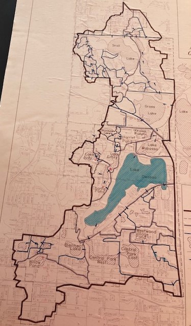
The map below depicts the water bodies that drain into Lake Owasso. To the west is Lake Emily which drains to Charlie Pond and then into Lake Owasso. (Charlie Pond now consists of an upper and lower water body to help further filtrate waters before entering Lake Owasso). Bennett Lake located southwest of the corner of Victoria and County Road C drains into the south end of Lake Owasso. Waters near Rice and South Owasso Blvd. drain into the southeast part of Lake Owasso (Lady Slipper Park). Lake Owasso drains into Lake Wabasso which drains into Grass Lake and then into the western segment of Lake Vadnais.
(This map is from the previous Watershed Organization – Grass Lake Watershed Management Organization (GLWMO). Hence the boundaries no longer represent the existing watershed organization) though the water flow patterns are still valid.

Footer

Contact

info@lakeowasso.org

(612) 552-1605

Recent Posts

  • 2025 LOA Annual Meeting
  • 2025 Treatment Renewal
  • Fluridone treatment updates for EWM
  • 2024 LOA Annual Meeting
  • 2024 Fluridone Treatment

Site Search

NO REPRESENTATIONS OR WARRANTIES. This Website is provided on an “as is” basis. Read Full Disclaimer »

Copyright © 2025 · Lake Owasso Association, Inc · Log in